Unit 1.5: Maritime Geography: EEZ & SLOCs
Indian Geography → Indian Geography → PHYSICAL FOUNDATIONS → PHYSICAL FOUNDATIONS → Location & Frontiers | Author: admin | Feb 11, 2026
1. Introduction & Significance Unit 1.5 (Maritime Geography: EEZ & SLOCs) is vital for UPSC Prelims (MCQs on zones, lengths, rights) and Mains (analytical questions on maritime security, blue economy, SAGAR doctrine). SSC/RRB/State PSC ask factual data (EEZ area, zones). High weightage in 2026 due to India's push for ocean resources (Sagarmala, deep-sea mining) and strategic chokepoints (Malacca Strait oil imports). Links to current schemes (Sagarmala ports) and geopolitics (Indian Ocean dominance). This is a 6–10 mark area — master zones, rights, and SLOCs for Prelims facts and Mains answers on maritime power.
2. Chronological/Geological Timeline
- 1982: UNCLOS (United Nations Convention on the Law of the Sea) adopted — defines EEZ, territorial waters, contiguous zone.
- 1995: India ratifies UNCLOS.
- 2009–2014: India submits extended continental shelf claim to UN (beyond 200 nm EEZ).
- 2014: Sagarmala initiative launched — focuses on port-led development in EEZ.
- 2020s: Deep Ocean Mission (2021) targets EEZ resources (polymetallic nodules).
- 2025–2026: Ongoing EEZ patrols; SLOC security amid Red Sea disruptions (Houthi attacks) and Malacca Strait importance.
3. Concept Deep Dive Maritime zones extend from baseline (coastline):
- Territorial Waters: 12 nautical miles (nm) — full sovereignty.
- Contiguous Zone: 24 nm — customs, immigration enforcement.
- Exclusive Economic Zone (EEZ): 200 nm — sovereign rights for resources (fishing, oil, minerals), other states have navigation freedom.
- Continental Shelf: Up to 350 nm (extended claim) — seabed resources. India's EEZ: ~2.02 million sq km (including islands); total maritime area larger with extended shelf. SLOCs (Sea Lines of Communication): Vital shipping routes for trade/energy; India's key ones pass through Indian Ocean (Malacca Strait ~80% oil imports, Strait of Hormuz, Bab-el-Mandeb). Chokepoints vulnerable to disruption. (Ref: NCERT Class 11 Fundamentals of Physical Geography Ch. on Oceans; Goh Cheng Leong Ch. on Oceans & Seas; Majid Husain Ch. 1 "Maritime Boundaries"; Oxford Atlas for EEZ maps).
4. Key Terminology Box
- Exclusive Economic Zone (EEZ): 200 nm from baseline; rights to explore/exploit resources.
- Territorial Waters: 12 nm; full sovereignty like land.
- Contiguous Zone: 24 nm; enforcement of customs/immigration laws.
- Continental Shelf: Seabed extension beyond EEZ (up to 350 nm) for resources.
- Sea Lines of Communication (SLOCs): Major maritime trade/energy routes.
- Chokepoints: Narrow passages on SLOCs (e.g., Malacca Strait).
- Baseline: Low-water line along coast for measuring zones.
- UNCLOS: 1982 convention governing maritime zones.
5. Important Factual Details
| Zone / Feature | Distance from Baseline | Rights / Purpose | India's Approx. Area / Length |
|---|---|---|---|
| Territorial Waters | 12 nm | Full sovereignty (land-like) | ~6,100 km mainland coastline |
| Contiguous Zone | 24 nm | Customs, fiscal, immigration control | — |
| Exclusive Economic Zone (EEZ) | 200 nm | Resource exploration/exploitation | ~2.02 million sq km |
| Continental Shelf (extended) | Up to 350 nm | Seabed/subsoil resources | Claim submitted to UN |
| Total Coastline | — | Mainland + islands | ~7,516 km (incl. islands) |
| Key SLOCs | Indian Ocean routes | Oil/energy imports (~80% via Malacca) | Malacca, Hormuz, Bab-el-Mandeb |
| Strategic Chokepoints | Narrow passages | Vulnerable to blockades | Malacca Strait critical |
6. Frequently Asked Exam Facts
- India's EEZ area: ~2.02 million sq km.
- Territorial waters: 12 nautical miles from baseline.
- EEZ rights: Resources (fishing, oil, minerals) but navigation free for others.
- UNCLOS year: 1982 (India ratified 1995).
- Longest coastline state: Gujarat (~1,600 km).
- Island EEZ contribution: Andaman & Nicobar + Lakshadweep significant.
- Key SLOC chokepoint for India: Malacca Strait (~80% oil imports).
- Sagarmala focuses on EEZ port development.
- Continental shelf extension: India claims beyond 200 nm.
- EEZ includes exclusive fishing/mineral rights.
7. Comparison Charts/Tables
| Zone | Sovereignty Level | Distance | Key Rights | Example in India |
|---|---|---|---|---|
| Territorial Waters | Full (like land) | 12 nm | All activities | Coastal fishing, security |
| EEZ | Sovereign rights (resources) | 200 nm | Exploration, exploitation | Oil/gas in Arabian Sea, Bay of Bengal |
| High Seas | None (international) | Beyond EEZ | Freedom of navigation | Deep-sea mining outside EEZ |
8. Spatial Context
- EEZ surrounds mainland coast (Arabian Sea west, Bay of Bengal east) and islands (Andaman & Nicobar east, Lakshadweep west).
- Key areas: Mumbai High (oil), Krishna-Godavari basin (gas), Andaman EEZ (potential minerals).
- SLOCs: Enter Indian Ocean via Malacca Strait (east), Hormuz (west Persian Gulf oil), Bab-el-Mandeb (Red Sea).
- Salem/TN relevance: TN east coast (Bay of Bengal) contributes to EEZ; Coromandel coast fishing; Salem inland but TN ports (Chennai, Tuticorin) link to EEZ trade.
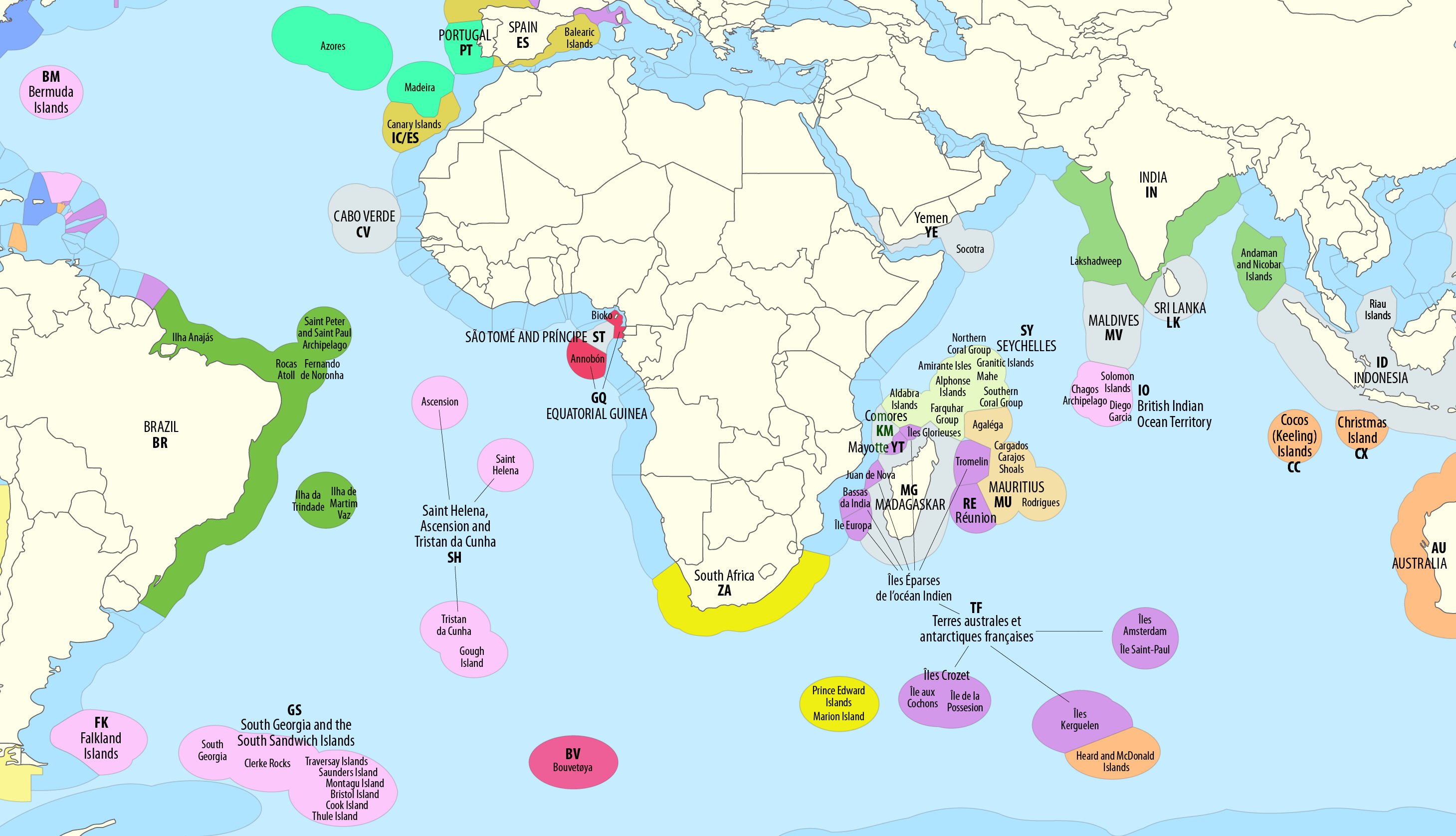
Image credit: Wikipedia via search, showing global EEZ map with India's zone highlighted in the Indian Ocean.

Image credit: Carnegie Endowment via search, illustrating sovereignty disputes and EEZ limits in Indian Ocean region around India.
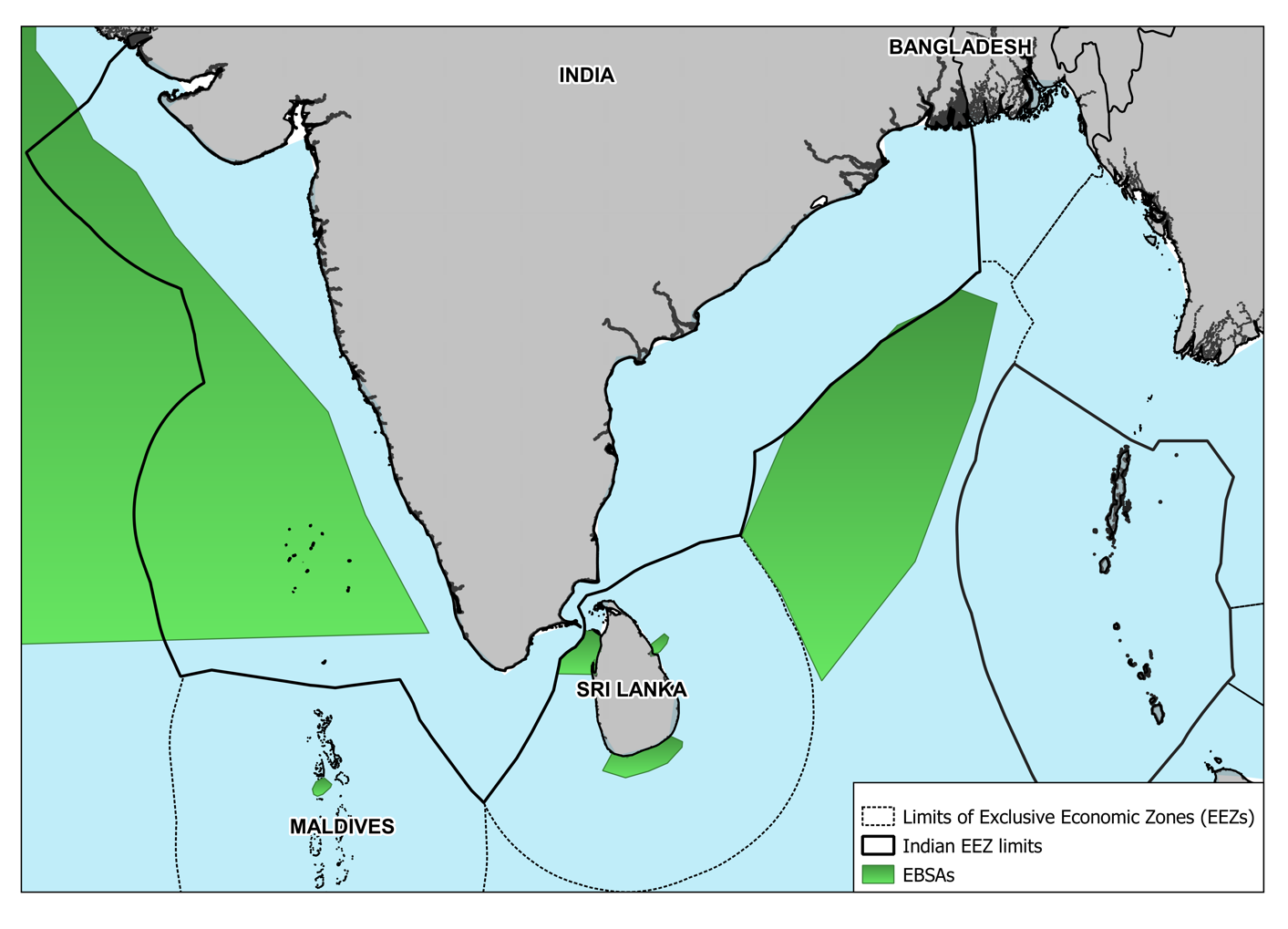
Image credit: National Maritime Foundation via search, showing India's EEZ boundaries with neighboring countries and EBSAs.
9. Flowchart Summary Baseline (coastline) ? Territorial Waters (12 nm: full sovereignty) ? Contiguous Zone (24 nm: enforcement) ? EEZ (200 nm: resource rights) ? High Seas (beyond: free navigation). Parallel: SLOCs ? Major routes (Malacca, Hormuz) ? Chokepoints vulnerable ? India's security focus (Sagarmala, naval presence).
10. Ultra-Short Exam Capsule
- EEZ: 200 nm, ~2.02 million sq km.
- Territorial waters: 12 nm full sovereignty.
- SLOCs: Vital Indian Ocean routes (Malacca key for oil).
- UNCLOS 1982 defines zones.
- India's EEZ includes islands (A&N, Lakshadweep).
- Chokepoints: Malacca, Hormuz, Bab-el-Mandeb.
TYPE 2: QUICK REVISION & EXAM TRICKS
1. Highlights & Tricky Points
- Key: EEZ = resources only, not full sovereignty (navigation free).
- Trap: "EEZ = territorial waters" — wrong; EEZ starts after 12 nm.
- Trap: "India's EEZ largest in Indian Ocean?" — No; Indonesia larger.
- Trap: SLOCs = trade routes, not borders.
2. Memory Aids/Mnemonics
- Zones distances: "12 Territorial, 24 Contiguous, 200 EEZ" ? "12-24-200: T-C-E" (Territorial Contiguous EEZ).
- SLOC chokepoints: "Malacca Hormuz Bab-el" ? "MHB: Malacca Hormuz Bab-el Mandeb".
- EEZ area: "2 million sq km — twice mainland" (approx 3.28M land vs 2M EEZ).
3. Confusing Concepts
- EEZ vs Territorial Waters: Territorial = full control (12 nm); EEZ = resource rights only (200 nm).
- Ships can pass freely in EEZ.
- EEZ vs Continental Shelf: EEZ = water column + seabed (200 nm); Shelf = seabed only (up to 350 nm extended).
- India claims extended shelf for minerals.
TYPE 3: PYQs & EXPECTED QUESTIONS
1. PYQ Vault
- UPSC Prelims 2018: The Exclusive Economic Zone extends up to? ? 200 nautical miles.
- SSC CGL 2019: India's EEZ is recognized under which convention? ? UNCLOS 1982.
- UPSC Prelims 2021: The maritime boundary of India extends up to how many nautical miles in EEZ? ? 200.
- RRB NTPC 2020: Which zone allows India exclusive rights for fishing and mining? ? EEZ.
- SSC CGL 2022: Territorial waters of India extend up to? ? 12 nautical miles.
- State PSC (TNPSC 2021): India's EEZ area is approximately? ? 2 million sq km.
- UPSC Prelims 2016: Under UNCLOS, the EEZ is? ? 200 nautical miles.
- RRB JE 2019: Contiguous Zone extends up to? ? 24 nautical miles.
- BPSC 2020: Which international agreement defines maritime zones like EEZ? ? UNCLOS.
- SSC MTS 2021: The key chokepoint for India's oil imports is? ? Malacca Strait.
2. 2026 Expected Questions
- What is the extent of India's Exclusive Economic Zone under UNCLOS?
- Name the zone beyond 12 nautical miles where India has resource rights but not full sovereignty.
- Which major SLOC chokepoint is critical for India's energy imports?
- How does India's EEZ contribute to the blue economy and Sagarmala initiative?
- What is the difference between Territorial Waters and EEZ in terms of rights?
- Which islands significantly expand India's EEZ in the Bay of Bengal?